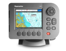
Raymarine A50 Chartplotter Features:
A50 5" Chartplotter
- 5'' sunlight viewable colour display
- High resolution VGA (640 x 480)
- IPX6 waterproof construction
- Tilt & swivel bracket with quick release and cable management
- Activate and control a Raymarine SPX Series autopilot directly from the A50's chartplotter screen
- Two NMEA 0183 Input and Output ports
A50 Chartplotter
- No preloaded cartography. Use optional Navionics Gold or Platinum charts.
- High speed chart redraw
- Chart Rotation Modes (Head up, Course up and North Up)
- 1200 Waypoints and 150 routes with unlimited waypoint and route storage using optional CompactFlash memory card
- High sensitivity internal WAAS GPS sensor
- Navionics Gold and Platinum capability
- 3D and satellite photo charts (with optional Platinum Chart Card)
- AIS target tracking (with optional AIS250 module)
A50 SIRIUS Weather & Audio (US only)
- SIRIUS Satellite weather and radio with optional SR50
- Graphical Nowrad radar, sea surface temperature, storm tracks, and more!
- SIRIUS Satellite radio capability. Set reminders for favourite songs and artists on over 130 SIRIUS radio channels.
A50 Engine Monitoring
- Connect NMEA 2000 compatible engines with SeaTalkNG
- Create customizable pages for engine data, trim tabs, instrument data, and more!
Raymarine A50 (E62184-EU) 5" Multifunction Display - European ChartsSpecifications:
General
- Data Display Capabilities: Chartplotter, CDI(Course Deviation Indicator), and customizable Data Bar display
- Dimensions: (W x H x D) 200 x 142 x 43mm
- Display (LCD) size: 5"
- Display colours: 256
- Display resolution: 640 x 480 pixels (VGA)
- Display type: Sunlight viewable colour TFT LCD
- Mounting methods: Tilt & Swivel Bracket (Panel Mount optional)
- Operating and non operating temperature limits: 14°F to 122°F (-10°C to 50°C)
- Power consumption: 6-8 Watts
- Voltage range: 10.7-18 volts (12v nominal)
- Waterproofing: IPX6 Standards
- Weight: 7.3lbs
- Approvals CE - conforms to FC Compliant with: Essential requirements of 1995/5/EC, 1989/336/EC. CFR47 Parts 2 & 80
- Humidity Limit: up to 95% at 35°C non-condensing
- Display windows: Chart, CDI, Data, Weather, and Engine Monitor
- Illustration: Screen and keypad: 0 to 100% in 64 steps Day/Night Mode
- Languages: English (UK), English (US), Italian, French, Spanish, German, Norwegian, Dutch, Swedish, Danish, Portuguese, Finnish, Icelandic, Chinese, Russian, Greek, Japanese, Korean
- System alarms: Alarm clock, Anchor, Arrival, Deep depth, MOB, Offtrack, Shallow depth, Temperature, Timer
- Navigation alarms: Arrival alarm, offtrack XTE alarm
AIS
- Target Symbols: Sleeping, activated, selected, dangerous and lost.
- Target Information: AIS vectors, safety critical data and full AIS data.
- Collision Avoidance: Safe zones and safety messages.
- Alarms: Local alarm messages, lost targets.
- AIS overlay: Switch AIS symbols on/off. Display heading/speed vectors and ROT. View detailed AIS data, safety critical target data, ALR and SRM messages. Set up a safe zone.
Chartplotter
- Waypoints: 1200 Waypoints with 16 character names. Additional waypoint storage available on CompactFlash cards.
- Waypoints Transfer: Waypoints database via NMEA and CompactFlash cards.
- Man Overboard (MOB Mode): Mark placed with course line; readout shows range, bearing, lat/lon of MOB and time elapsed since MOB
- Screen Functions: Full, half and quarter screens available dependant on function. Also 3 window page with 2 x 1/4 page windows and 1 x 1/2 page window
- Cartography: No preloaded cartography. Compatible with Navionics Gold & Platinum Charts on CompactFlash cards
- Presentation Modes: Head up, Course up or North up (selectable True or Magnetic). Relative, Autorange or True Motion. Screen offset. 3D synchronisation.
- Routes: 150 routes with 50 waypoints per route. Additional routes can be stored CompactFlash cards
- Track History: Ability to record the current track with a maximum of 10,000 trackpoints, or save up to 10 tracks with up to 1000 trackpoints in each stored in the units internal memory. Additional tracks can be stored CompactFlash cards
- 3D/Chart Synchronisation: To synchronise 3D and 2D chart scales and orientation.
- Aerial overlay: Overlay of aerial photograph on the chart
- Navigation information: Own boats position in lat/lon, XTE, TTG and SOG/COG selectable. Bearing and distance to waypoint. Bearing and distance to cursor and ETA
- 3D Presentation Modes: Active motion mode, planning mode, Adjust rotation and pitch, port, starboard, forward and aft view, multiple views, Vessel offset
- 3D Display: Declutter, Transducer cone, Depth scale, Waypoint name, Adjust exaggeration, 3D view locator
Instrument and Engine Data
- Data pages: 5 pages available. Pre-defined (Navigation, Waypoint, Route, Fishing or Sailing) or user-configured.
- Data available: Vessel position, active waypoint, TTG, VMG - Waypoint, depth, COG SOG, heading, speed, set/drift, trip, log, ground log, ground trip, rudder, local time and date, sea temperature, app wind, true wind, VMG wind, ground wind XTE, compass, locked heading, wa
- Engine pages: 5 pages available. Pre-defined (engine, engine and fuel, fuel resources, engine and resources, twin engines or triple engine support) or user-configured.
- Engine data available: Tacho, boost pressure, alternator, oil pressure, coolant temperature, engine hours, fuel level (tanks 1 & 2), fuel rate, total fuel, load, trim tab, engine trim and genset
Interfaces
- NMEA 0183 Interface: 2 Input and Output ports
- NMEA 0183 Input messages: GLL, GGA, GLC, GTD, VTG, BWC, BWR, RMA, RMB, RMC, XTE, VHW, HDG, HDM, HDT, DBT, DPT, APB, VLW, MWV, WPL, RTE, DSC and ZDA. Selectable to 4800, 4800 Navtex, 9600 Navtex or 38,400 AIS
- MEA 0183 Output messages - user selectable: APB, BWC, BWR, DBT, DPT, GGA, GLL, MTW, RMA, RMB, RMC, RSD, TTM, VLW, VHW, VTG, WPL, VHF/DSC and ZDA
- SeaTalkNG/NMEA 2000: 1 SeaTalkng connector. SeaTalkng to NMEA2000 adapter available
NAVTEX
- Alerts: Incoming message (selectable categories)
- Message list: Sorting
|
 Loading... Please wait...
 A-Series Music...A Taste of Incredicle Raymarine A-Series Multifunctional Displays
 Raymarine A-Se...Raymarine A-Series multifunctional dispays. GPS Chartplotters ...
 Raymarine A-Se...Raymarine A-Series multifunctional dispays. GPS Chartplotters ...
 Raymarine A-Se...Raymarine A-Series multifunctional dispays. GPS Chartplotters ...


