Loading... Please wait...
Categories
 New Products
-
 $750.00
-
 $102.00
-
 $117.00
-
 $162.00
-
 $87.00
Our Newsletter
![]()

![]()
- Home
- Garmin Marine Electronics
- Garmin Mediterranean Southeast Charts – BlueChart g3 Vision microSD/SD - 010-C0774-00
- Home
- Garmin Marine Electronics
- Garmin Marine Audio
- Garmin Mediterranean Southeast Charts – BlueChart g3 Vision microSD/SD - 010-C0774-00
- Home
- Garmin Marine Electronics
- Garmin Marine Audio
- Garmin Audio Accessories
- Garmin Mediterranean Southeast Charts – BlueChart g3 Vision microSD/SD - 010-C0774-00

)
Product Description
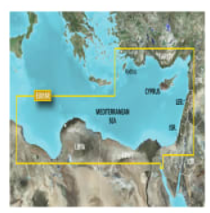
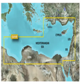
Garmin Mediterranean Southeast Charts – BlueChart g3 Vision microSD/SD
(010-C0774-00)
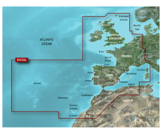
Mediterranean Southeast Charts provide detailed navigational mapping for safe and accurate sailing. Perfect for recreational and professional mariners, offering updated routes, ports, and coastal features across the southeast Mediterranean region.Garmin BlueChart g3 Vision Mediterranean Southeast - DescriptionThese charts deliver comprehensive marine navigation information, including coastal topography, depth contours, and navigational aids. Ideal for planning voyages, monitoring positions, and ensuring safe passage in the southeast Mediterranean waters. 1. Accurate Coastal Mapping Charts provide precise details of coastlines, harbors, and navigational aids to help sailors navigate safely. Updated regularly to reflect changes in the maritime environment. 2. Detailed Depth Contours Depth contours and underwater topography are clearly mapped, allowing for safe anchoring, maneuvering, and route planning in coastal and offshore waters. 3. Comprehensive Navigational Aids Includes lighthouses, buoys, and markers, helping mariners maintain situational awareness and comply with maritime safety regulations. Garmin BlueChart g3 Vision Mediterranean Southeast - Key Features1. Extensive Coverage Covers the southeast Mediterranean region, including major ports, marinas, and coastal areas. Ideal for long voyages or local cruising. 2. Updated Information Charts are regularly revised to reflect new maritime data, ensuring accurate and reliable navigation. 3. Easy Integration Compatible with Garmin chartplotters and other supported marine navigation devices. Enables seamless loading and use onboard. 4. Enhanced Safety Provides detailed information for safe passage, including hazards, restricted areas, and depth variations. Enhances situational awareness for all types of vessels. Garmin BlueChart g3 Vision Mediterranean Southeast – What is In The BOX:
File Information: The file size of this download and space required on device or microSD™/SD™ card is 982.75 MB. If this download does not fit on your device, data may be saved on a microSD/SD card (recycled microSD cards may be used to program map data). Garmin BlueChart g3 Vision Mediterranean Southeast - Specifications
General Features
|